Editorial Picks
9 Hidden Walking Routes in Gangnam (Most Tourists Skip)
Nine quieter walking circuits I keep coming back to in Gangnam — residential alleys, a side-stream most visitors skip, a metasequoia path on the southern edge, and the diagonals locals use to get places without ever surfacing on Garosu-gil.
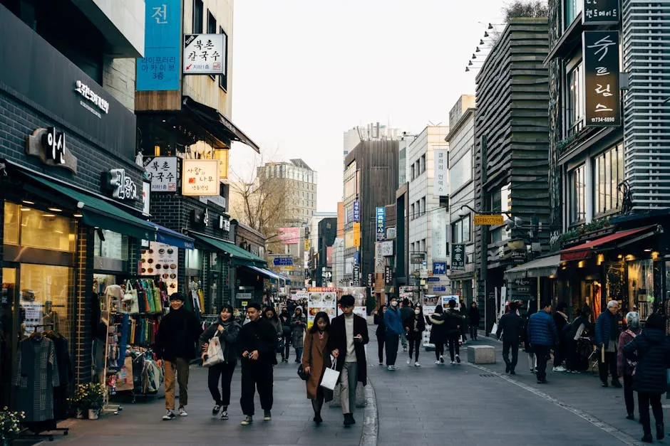
I started keeping notes on Gangnam walking routes on my third trip, mostly because I noticed I had stopped using the loud streets entirely and could not actually explain to anyone where I had been spending my afternoons. Six trips in, the notes have hardened into a working set of nine quieter circuits I rotate through depending on the weather, the time of day, and whether my face is looking like a face yet after the morning's appointment. None of these are secret in any meaningful sense — locals walk them daily, and the buyers and clinicians I have asked all know the same alleys — but they are quieter than the obvious tourist axis of Gangnam Station, Garosu-gil, and the Apgujeong main strip, which is the only sense in which they are hidden. This is a categorical read, organized roughly by neighborhood and by the kind of day each route earns. The order is not a ranking; it is the order I would walk them on a real week, starting from the Apgujeong-side cluster I tend to stay in. The right first walk for any given day is the one closest to where your day is starting and the one whose surface and pacing match what your face and feet can handle. Anything sharper than that is brochure language, and the brochure language is mostly the part I am trying to leave out of this guide.
Why Gangnam walking runs differently from the rest of Seoul
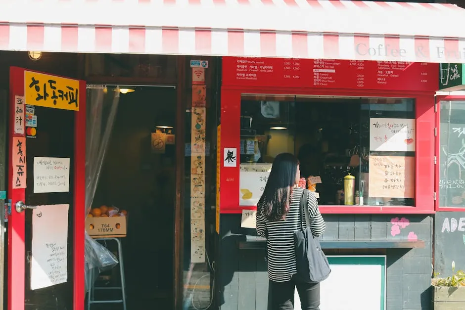
Gangnam walking runs differently from Hongdae, Bukchon, or Seongsu because the neighborhood was largely planned in the 1970s and 1980s on a wide-block grid rather than around an older village footprint, which means the quieter streets sit at predictable intervals between the loud ones and the residential alleys are unusually flat by Seoul standards. That is the basic shape of it. Hongdae walking is denser, narrower, and steeper. Bukchon walking is older, hillier, and visually busier per block. Seongsu walking is industrial-converted and has more uneven curbs than visitors expect. Gangnam's quieter streets are, by comparison, broad enough for two people to walk side by side without stepping aside for traffic, gently graded for the most part, and laid out in a way that you can navigate without phone-checking once you have done a route twice. What keeps me coming back to walking here, specifically, is recovery-day compatibility. After a morning Ultherapy appointment, my face is genuinely swollen for about forty-eight hours and tender for closer to seventy-two, which means the walks I want on those days are flat, shaded, low-stimulation, and routable into a soft bench or a quiet café within twenty minutes if I need to stop. Most of the routes in this guide are built around that constraint, which is why the southern Gangnam metasequoia path and the side-stream walk get more use from me than the headline ones. On a non-recovery day I will walk Garosu-gil and the Apgujeong main strip with everyone else, and they are perfectly good streets; on a recovery day, the quieter alleys are not optional, they are the only walks that actually work. A practical note before the list. Most of these routes have rough mile and kilometer estimates baked in, which I have measured on my own watch across multiple trips rather than copied from any official source. Surface is asphalt or sidewalk concrete throughout, almost no cobble, occasional brick. Shade is decent on the tree-lined routes and limited on the side-stream stretches in summer; a hat helps in either case, and on post-Ultherapy days a hat is non-negotiable for sun reasons that the clinic will explain at discharge. None of these walks require any particular mobility level beyond comfortable flat walking; the steepest grade in the set is gentle enough that an unhurried older walker would handle it without trouble. I have walked all nine on swollen-face days at least once, which is the most honest stress test I can offer.
The residential alley behind Apgujeong Rodeo Station
The first route on my rotation is a quiet residential alley two blocks south of Apgujeong Rodeo Station that runs gently east for roughly ten minutes before opening into a small neighborhood park, with low-rise apartments on both sides, mature trees overhanging the sidewalk, and almost no commercial frontage for the entire stretch. The street is wide enough to walk side by side, the sidewalk is in good repair, and the only foot traffic is residents walking dogs in the morning and elementary-school kids returning from school in the afternoon. I have walked this alley dozens of times across six trips and have never once felt rushed by traffic or crowded by other walkers, which puts it among the quietest streets I have found at this distance from a major subway exit anywhere in Seoul. The pacing is gentle. End to end the route runs about 800 meters, or roughly half a mile, and unhurried walking with a few stops at a bench or two extends easily to twenty-five minutes. The grade is essentially flat, with a single very slight uphill in the middle third that you would not notice without looking for it. Surface is sidewalk concrete in good condition, no cobble, occasional brick at the cross-streets. Shade in summer is decent because the apartment-block trees are mature, and in winter the alley catches enough afternoon sun that it stays comfortable into early evening. Crossings are low-stress because the side-streets that cut through have light traffic and no rushed driver behavior; I have never had to wait more than ten seconds at a crossing. The trade-offs are specific. There is essentially no commerce on this route — no cafés, no shops, no restaurants — which means it functions as a connector or a quiet morning loop rather than as a destination walk in itself. If you want to chain the alley into a longer afternoon, the small park at the eastern end opens onto a side-street that connects to the Apgujeong main strip in another five minutes, which is the way I usually walk it on non-recovery days. On recovery days I just turn around at the park and walk back, which is a perfectly serviceable forty-minute round trip with a single bench stop in the middle. The right reason to use this route is when you want a flat, shaded, residential walk within ten minutes of Apgujeong Rodeo Station and you do not need the walk to do any other work for you; the wrong reason is to expect anything to look at, because the street is honestly residential and that residential quality is the entire point.
The Yangjaecheon side-stream from Maebong to Yeoksam
The second route on my rotation is a Yangjaecheon side-stream walk that runs from Maebong Station northward along the stream bed toward Yeoksam, with the stream itself maintained as a linear park, paved walking and bike lanes on both banks, and the kind of gentle south-of-Gangnam-Boulevard quietness that Yangjae generally has more of than Apgujeong. The stream is shallow enough that you can hear it clearly on a quiet weekday morning, and the planted edges run alternating willow, cherry, and metasequoia depending on the segment. Cherry blossom season here, late March into early April, is genuinely beautiful and noticeably less crowded than the headline Yeouido or Han River sites, which is the reason locals tend to use it on the off-peak weekday mornings rather than the obvious tourist windows. The pacing is flexible by design. The walkable segment from Maebong toward Yeoksam runs about 2.4 kilometers one way, or roughly 1.5 miles, with a turn-around at any of three small bridges that cross the stream at convenient intervals. End-to-end one way takes me about thirty-five minutes at unhurried pace; a there-and-back loop runs seventy to eighty minutes with two short bench stops, which is about the longest walk I will plan on a recovery day. The surface is paved walking lane separated from the bike lane by a painted line, in good condition the entire length, with occasional wooden boardwalk segments at the planted-edge stretches. The grade is essentially flat the entire way; the stream slopes gently downward but the walking lanes are graded to compensate. The trade-offs are seasonal and weather-driven. After heavy rain the lower walking lanes flood for a day or two, at which point the upper lanes work but the experience changes. In peak summer the shade is decent on the willow segments and limited on the open stretches, and a hat is non-negotiable on a sunny day. The mosquito season runs roughly late June through August, and the upper banks are noticeably better than the lower ones for that reason. Cherry blossom weeks see a meaningful increase in foot traffic that, while still less than the headline sites, is enough to shift the experience toward 'pleasant urban park' rather than 'quiet stream walk.' Card is fine for the small cafés near the Yeoksam exit if you want to chain the walk into a coffee stop, English is workable at most of the cafés, and the route is well-signed in Korean and English at the bridge crossings. The right reason to walk this route is to find a longer flat circuit with running water and decent shade within fifteen minutes of central Gangnam; the wrong reason is to expect dramatic scenery, because the experience is a quiet linear park rather than anything iconic.
The Dosan Park inner loop with two cafés
The third route on my rotation is the inner loop of Dosan Park itself, a small green space in the middle of the Apgujeong-Sinsa cluster that I treat as a forty-minute reset rather than a destination walk in the traditional sense. The park is roughly oval, the inner walking path is paved and tree-lined, and the surrounding blocks are dense with small cafés that the park itself does not have inside its perimeter. I will usually walk the inner loop twice, sit on a bench for ten minutes, and then chain the walk into one of the side-street cafés on the eastern or southern edge of the park for a soft drink before continuing the afternoon. This is the route I default to on a high-stimulation day when I do not want to commit to a longer route but still need to be outside. The pacing is intentionally short. A single inner loop runs about 600 meters, or roughly 0.4 miles, and an unhurried double loop with a bench stop comes in around twenty-five minutes total. The grade is flat with one barely-perceptible rise on the southwestern arc. Surface is paved walking path in good repair throughout, no cobble, occasional brick at the entrances. Shade is excellent on the inner loop because the perimeter trees are mature and the canopy closes overhead on the eastern half, which makes the loop comfortable on a sunny summer afternoon when the surrounding streets are uncomfortably bright. Crossings within the park itself do not exist; the only road crossing is at the entry, which is a stoplight intersection with adequate pedestrian timing. The trade-offs are scale and crowd-time. Dosan Park is small enough that a single loop is a quick walk rather than a real walk, which is why the double-loop-plus-café framing matters more than the loop itself; without the bench stop and the café chain, the route is barely twelve minutes, which is not enough on most days. The park sees meaningful weekend crowd density on a sunny Saturday afternoon, and on those days the experience shifts toward 'busy urban park' rather than 'quiet inner loop'. Weekday mornings before 10 a.m. and weekday afternoons after 4 p.m. are the windows I prefer, and on a swollen-face day I will avoid the weekend entirely. Card and English are non-issues because the surrounding cafés are essentially Apgujeong cafés and their service standard is the area average, which is excellent. The right reason to use Dosan Park as a walk is when you want a short, shaded, central reset that chains into a café without a transit step; the wrong reason is to expect a long walk, because the perimeter is honestly small and the value lives in the chain rather than the loop alone.
The Sinsa-dong tree-lined diagonal nobody uses
The fourth route on my rotation is a tree-lined residential diagonal in Sinsa-dong that cuts northeast from a side-street near Sinsa Station toward the southern edge of Apgujeong, running roughly parallel to but two blocks east of Garosu-gil, with mature plane trees overhead and almost no commercial frontage along its length. The diagonal exists because the Gangnam grid is not perfectly square in this segment, and the result is a ten-minute walk through a quietly residential corridor that locals use as a connector between the two neighborhoods without ever surfacing onto the loud streets. Most visitors never find it because Naver Maps' default routing prefers the main streets, and unless you have walked it once intentionally you would not know to ask for it. The pacing is consistent and short. End to end the diagonal runs about 700 meters, or roughly 0.45 miles, and unhurried walking comes in at thirteen to fifteen minutes. The grade is flat, with a single slight uphill at the Apgujeong-end approach that adds maybe ninety seconds. Surface is sidewalk concrete in good repair throughout, with the standard Korean sidewalk-tile sections at building entrances. Shade is excellent the entire length because the plane trees were planted decades ago and the canopy is mature; this is one of the best summer-shade walks I have found in Gangnam, and the difference between this diagonal and the parallel main streets on a hot afternoon is meaningful. Crossings are low-stress because the cross-streets carry light traffic and the residents drive slowly through their own neighborhood. The trade-offs are mostly directional. The diagonal only works as a route in one of two directions — northeast from Sinsa toward Apgujeong, or southwest the reverse — which means it functions as a connector between specific neighborhoods rather than as a standalone loop. If you are not walking between Sinsa and Apgujeong, the diagonal does not solve a problem you have. On a recovery day I will walk it as part of a longer chain that includes the Apgujeong residential alley on one end and a quiet café in southern Sinsa on the other, which makes for a thirty-five-minute total route with two soft stops. There is essentially no commerce on the diagonal itself, which is the same trade-off as the residential alley behind Apgujeong Rodeo — meaning you should not plan it as a café walk, because there are no cafés. The right reason to use this diagonal is when you need to get from Sinsa to Apgujeong on a hot day or a recovery day and you want to do it under shade on a quiet residential street; the wrong reason is to expect anything to look at, because, again, the residential quality is the entire point.
The Yangjae Citizens' Forest metasequoia path
The fifth route on my rotation is the metasequoia path inside Yangjae Citizens' Forest on the southern edge of Gangnam, about a fifteen-minute drive from Apgujeong or twenty-five minutes by subway with one transfer, with a planted corridor of mature metasequoia trees running roughly half a kilometer through the park's interior and a network of perpendicular paths that loop back toward the main entrance. The forest itself is large by central-Seoul standards, about half a square kilometer of mostly-shaded park, and the metasequoia path runs through the center as a kind of cathedral of trees that locals use for quiet morning walks and weekend family time. I treat this as my long-recovery-day walk on the second or third day after Ultherapy when I am ready to commit to a forty-minute outdoor stretch. The pacing earns the trip. The metasequoia path runs about 500 meters one way, or roughly 0.3 miles, and a there-and-back walk with a perpendicular loop branch comes in at around 1.4 kilometers, or 0.9 miles, total. End-to-end with two bench stops takes me forty to forty-five minutes at unhurried pace. The grade is flat the entire length; this is one of the flattest park walks at this scale in central Seoul. Surface is mostly compacted earth and gravel with paved walking path on the perpendicular loops, in good condition, with occasional wooden boardwalk at the wetter low-lying sections. Shade is excellent on the metasequoia path itself because the trees are mature and the canopy closes completely overhead, and decent on the perpendicular loops with mixed deciduous shade. The forest is genuinely cooler than central Apgujeong on a hot summer afternoon by what feels like several degrees, which is meaningful on a recovery day. The trade-offs are travel time and weekend crowding. The fifteen-to-twenty-five-minute trip to reach Yangjae is a real cost on a recovery day when you are not feeling great, and I would not make this walk if I were tired enough that the transit itself would be unpleasant. Weekends, particularly spring and autumn weekends in good weather, see meaningful family-with-kids density that shifts the experience toward 'busy weekend park' rather than 'quiet metasequoia path'. Weekday mornings before 11 a.m. and weekday afternoons after 3 p.m. are the windows I prefer, and a sunny weekday morning here is one of the most genuinely calming outdoor experiences I have found in Seoul. There is a small café near the main entrance with workable English and a clean restroom, which matters on a longer walk. The right reason to make the trip to Yangjae is for a flat, deeply shaded, low-stimulation forty-minute walk on a recovery day when you are ready for an outdoor stretch; the wrong reason is to make the trip when you do not have at least ninety minutes of total time available, because the transit-plus-walk math does not work below that threshold.
The Hangang back-walk from Banpo to Apgujeong
The sixth route on my rotation is a Han River back-walk that follows the upper bank from the Banpo Bridge area east to roughly the Apgujeong stretch, running on the inland side of the riverside parkland rather than along the headline waterfront promenade itself, with mostly residential apartment-block frontage on one side and the riverside park's tree line on the other. Most visitors who walk along the Han walk the waterfront promenade, which is the obvious choice and a perfectly good walk on a non-recovery day; the back-walk one tier inland is meaningfully quieter, has slightly better shade in summer, and skips the bike-lane crossings that the waterfront has every few hundred meters. I learned this routing from a coordinator on my second trip, and it has been my default Han River walk since then. The pacing scales to your day. The back-walk segment from Banpo to roughly the Apgujeong access point runs about 3.2 kilometers, or roughly 2 miles, end to end, which at unhurried pace comes in at fifty-five to sixty-five minutes one way. On a longer day I will walk one-way and ride or taxi back; on a shorter day I will walk to a midpoint and turn around for a sixty-minute round trip. The grade is essentially flat with a few brief rises at the bridge underpasses. Surface is mostly paved sidewalk and park-edge walking path, in good condition, with one short cobble section near a residential complex that is short enough to be a non-issue. Shade is decent on the tree-line side and limited on the apartment-block side; I tend to walk on the tree-line side in summer for that reason, which is also the side with the better river views through the gaps in the planted edge. The trade-offs are about distance and turn-around logistics. End-to-end is genuinely a long walk for a recovery day, which is why I usually only do the full 3.2 kilometers on day three or later after Ultherapy when I am back to normal pacing. The turn-around bridges are spaced widely enough that you cannot bail every few minutes the way you can on the Yangjaecheon stream walk, which means you should commit to a target distance before you start. Restrooms are available at the Banpo and Apgujeong access points and at one mid-route public facility; cafés are limited on the back-walk side and more available if you cut up to the apartment-block streets, which adds a few minutes per stop. The waterfront sunset and the Banpo fountain are the things this back-walk does not deliver, because you are inland of the waterfront for the entire length and the river is visible only through the planted edge; if those are what you want, the front waterfront walk is the better choice. The right reason to use the back-walk is when you want a long flat shaded Han-adjacent walk without the bike-lane crossings and the higher visitor density of the waterfront; the wrong reason is to expect waterfront views, because the back-walk is structurally one tier inland and that is the entire point.
The Cheongdam-dong embassy quarter loop
The seventh route on my rotation is a quiet residential loop through the eastern Cheongdam-dong embassy and consulate quarter, with low-rise residential buildings, occasional small embassies tucked into otherwise residential blocks, mature street trees, and the kind of unusually clean and quiet residential atmosphere that Cheongdam generally has more of than the rest of Gangnam. The loop itself is irregular because the Cheongdam grid bends to follow older block lines, but the route I walk is a roughly rectangular circuit of about 1.2 kilometers, or 0.75 miles, that takes me thirty to thirty-five minutes at unhurried pace with one bench stop. The pacing is steady and short. Surface is sidewalk concrete in excellent repair throughout, which is a Cheongdam pattern — the residential streets here are noticeably better-maintained than the equivalent streets in Apgujeong or Sinsa-dong, and the difference is visible block by block. The grade is gentle with one slight rise in the middle third that adds maybe two minutes. Shade is decent on the tree-lined arms of the loop and limited on the cross-streets between residential blocks; on a sunny summer afternoon I tend to walk this loop counterclockwise to maximize the shaded segments in the early stretch. Crossings are very low-stress because the residential traffic is light and the drivers are slow, which I notice as a meaningful comfort difference compared to busier neighborhoods. The trade-offs are commercial-thinness and walking-purpose. There is essentially no commerce on this loop — no cafés, no shops, almost no restaurants — and the embassy-quarter quietness means there are not even many people on the sidewalks, which can feel pleasant on a recovery day or slightly empty on a normal day depending on your mood. The route works best as a connector between the Cheongdam vintage shops on one end and the Cheongdam hotel cluster on the other, or as a quiet residential extension to a Dosan Park afternoon. There are no public restrooms on the loop itself, which matters on a longer walk; I plan accordingly and use the hotel or café on either end. The right reason to walk this loop is when you want a quiet, well-maintained, residential thirty-minute stretch on the eastern side of Cheongdam without surfacing onto the louder streets near Cheongdam Bridge; the wrong reason is to expect anything to do, because the route is structurally a residential quiet-walk and that quiet is the entire point.
The Seonjeongneung tomb-park perimeter walk
The eighth route on my rotation is the perimeter walking path around Seonjeongneung, a UNESCO-listed Joseon-dynasty royal tomb park tucked unexpectedly between office towers near Seolleung Station, with a paved walking path that follows the perimeter of the tomb grounds on the inside of the park's boundary wall and a separate inner path through the wooded tomb mounds themselves. I usually walk only the perimeter, which is about 1.6 kilometers, or 1 mile, and runs through some of the densest old-growth tree cover anywhere in central Gangnam. The fact that this kind of forested tomb park exists in the middle of an office district is genuinely unusual, and the contrast between the wooded interior and the surrounding city-business architecture is one of the things that makes the walk feel worthwhile. The pacing is intentionally slow. The perimeter walk runs about thirty-five to forty minutes at unhurried pace with one bench stop, and a longer chain that includes the inner tomb-mound path adds another twenty minutes. The grade is gentle throughout, with two slight rises at the tomb mounds themselves that are both very modest. Surface is paved walking path on the perimeter, compacted earth and gravel on the inner mounds path, in good condition throughout. Shade is excellent on the perimeter the entire length because the old-growth trees close the canopy completely, and the temperature inside the park on a hot summer afternoon is noticeably lower than the surrounding office-district streets in a way that matters on a recovery day. Crossings within the park do not exist; the only road crossing is at the park entrance, which has adequate pedestrian timing. The trade-offs are entry fee and operating-hour limitations. Entry costs a small fee, currently around 1,000 KRW for adults, payable at the gate in cash or card; the park is open from morning through early evening with seasonal closing-time variation, and is closed on Mondays, which I have walked up to twice and had to reroute. The fee and hours are not significant frictions in absolute terms, but they are real and should be checked before committing to the walk on a tight schedule. The park is small enough that the perimeter walk is the entire experience; it does not chain easily into another route within walking distance, which is why I treat it as a standalone forty-five-minute outing rather than as a segment of a longer day. Restrooms are available at the entrance, English signage is workable for the major tomb-mound markers but limited elsewhere, and the on-site brochure includes a tolerable English version. The right reason to walk Seonjeongneung is for a deeply shaded forty-minute royal-tomb-park experience that contrasts sharply with the surrounding office district and feels nothing like the rest of central Gangnam; the wrong reason is to expect a long walk, because the perimeter is honestly small and the value lives in the contrast and the canopy rather than the distance.
The Gangnam-Yangjaecheon connector morning walk
The ninth route on my rotation is a connector morning walk that links the southern end of central Gangnam to the Yangjaecheon side-stream walk via a quiet sequence of residential streets and a small connecting park, run as a single end-to-end ninety-minute walk on a normal-pacing day or split into two thirty-minute halves on a recovery day. This is the route I use to start a long Saturday morning when I want to be walking by 7 or 8 a.m., before the cafés open and before central Gangnam wakes up, and want a route that builds gradually from quiet residential to fully linear-park before reaching a coffee stop near Yeoksam. The pacing has structure to it. The connector itself runs about 1.4 kilometers, or 0.9 miles, from the Apgujeong residential cluster south through Yeoksam and Maebong to the Yangjaecheon entry point, and chains into the stream walk for an additional 2 kilometers if you want the full ninety-minute version. The grade is gently downhill on the southbound direction (Apgujeong to Maebong loses about 25 meters of elevation gradually), which makes the morning version unusually pleasant; the return walk would be uphill and is why I usually subway back from Yeoksam if I have done the full version rather than walking the connector in reverse. Surface is sidewalk concrete throughout, in good condition. Shade is mixed — decent on the residential segments with mature street trees, limited on the cross-streets, excellent on the stream-walk segment if you reach it. The trade-offs are timing and return-trip logistics. The connector works best in the early morning before traffic and pedestrian density build up; after about 10 a.m. on a weekday the cross-streets become busier and the experience changes. Saturday mornings before 9 a.m. are my favorite window and Sunday mornings before 9 a.m. are the quietest. Returning from the Yangjaecheon end requires either subway back from Yeoksam (one transfer to Apgujeong, about twenty minutes) or a taxi (about ten to fifteen minutes), neither of which is particularly expensive but both of which add planning. There are essentially no cafés open before 8 a.m. along the connector itself, which means a coffee stop has to wait until you reach the Yeoksam end of the stream walk, where the early-opening cafés start at around 7:30 a.m. The right reason to use this connector is for a structured ninety-minute Saturday morning walk that ends at a quiet stream-walk café rather than at central-Gangnam crowd density; the wrong reason is to use it as a midday route, because the connector is honestly built for the early-morning-into-stream-walk shape and does not work as well at other times.
- Best window: Saturday/Sunday morning, 7-9 a.m.
- End-point coffee: small cafés at the Yeoksam stream-walk exit, opening around 7:30 a.m.
- Return: subway one-transfer (~20 min) or taxi (~10-15 min) back to Apgujeong cluster
- Recovery-day version: split connector and stream walk into two separate days
Side-by-side: the nine routes on a single comparison
The matrix below is categorical — it identifies operational shape, not relative quality, and the cells should be read as descriptive rather than as a ranking. Distance, shade, surface, and best-window are based on my own watch and notes across multiple trips rather than any official source, and the right walk for any given day is the one whose pacing and surface match what your face and feet can handle that morning. Anyone telling you otherwise is selling the brochure.
| Route | Neighborhood | Distance | Grade | Shade | Best window | Recovery-day fit |
|---|---|---|---|---|---|---|
| Residential alley | South of Apgujeong Rodeo | 0.5 mi (one way) | Flat | Decent (mature trees) | Anytime weekday | Excellent |
| Yangjaecheon side-stream | Maebong to Yeoksam | 1.5 mi (one way) | Flat | Mixed | Weekday morning/late afternoon | Excellent |
| Dosan Park inner loop | Apgujeong-Sinsa | 0.4 mi (per loop) | Flat | Excellent | Weekday morning before 10 a.m. | Good (short) |
| Sinsa diagonal | Sinsa to Apgujeong | 0.45 mi (one way) | Flat | Excellent (plane trees) | Anytime weekday | Excellent |
| Yangjae metasequoia path | Yangjae Citizens' Forest | 0.9 mi (loop) | Flat | Excellent (canopy) | Weekday morning before 11 a.m. | Excellent (day 2-3) |
| Han River back-walk | Banpo to Apgujeong | 2.0 mi (one way) | Mostly flat | Mixed (tree-line side better) | Late afternoon, off-peak | Day 3+ |
| Cheongdam embassy loop | Eastern Cheongdam-dong | 0.75 mi (loop) | Gentle | Mixed | Weekday afternoon | Good |
| Seonjeongneung perimeter | Seolleung area | 1.0 mi (perimeter) | Gentle | Excellent (old growth) | Weekday, not Monday | Excellent |
| Gangnam-Yangjaecheon connector | Apgujeong to Maebong | 0.9-2.2 mi (variable) | Gently downhill SB | Mixed | Weekend morning before 9 a.m. | Split version only |
Frequently asked questions
A few questions come up consistently from American friends planning a treatment trip who want to know which of these walks to actually slot into their week. The honest answers are below, and they are honest in the same direction the rest of this guide is — categorical rather than ranked, with the trade-offs surfaced rather than hidden, and grounded in what has actually worked for me across multiple trips rather than in what would sound best on a brochure.
“The right walk for any given day is the one whose surface and pacing match what your face and feet can handle that morning. Everything else is brochure language.”
Notes from a returning California regular, sixth trip
Frequently asked questions
Which of these walks works best on a swollen-face Ultherapy recovery day?
The residential alley behind Apgujeong Rodeo Station (), the Sinsa-dong tree-lined diagonal (), and the Seonjeongneung perimeter walk () are my top three for swollen-face days because they are flat, well-shaded, low-stimulation, and routable into a soft turn-around within twenty minutes if needed. The Yangjae metasequoia path () is better starting day two or three after the appointment when you are ready for a longer outdoor stretch. The Han River back-walk () and the full Gangnam-Yangjaecheon connector () are too long for a true recovery day and should wait until you are back to normal pacing.
How early in the morning is too early to walk these routes safely?
Most of these routes are walkable from roughly 6 a.m. onward without safety concerns; Gangnam is a low-crime urban environment with active early-morning use of public spaces by older walkers, dog-walkers, and runners. The exceptions are the more isolated stretches of the Han River back-walk () and the Yangjae metasequoia path (), where I prefer to start after 7 a.m. for ambient light and foot-traffic comfort rather than for any specific safety issue. Park entries (Dosan, Yangjae, Seonjeongneung) follow seasonal opening hours that are worth checking before committing; Seonjeongneung in particular has a defined gate-opening time that is later than most park entries.
Are any of these walks navigable without using my phone for directions?
Routes , , , and are simple enough geometrically that you can walk them once with phone navigation and then re-walk them from memory on subsequent visits without checking. Routes , , and are linear-park or perimeter-based and are well-signed enough at junctions that you do not need phone navigation past the initial entry point. Routes and are diagonals and connectors that are harder to memorize on a single walk; I tend to use phone navigation for the first two or three trips on those before they become muscle memory. None of these routes require continuous phone-checking the way some of the older Bukchon alley walks do, which is one of the things that makes Gangnam walking generally easier than other Seoul neighborhoods.
What about restrooms and water stops on the longer routes?
The Yangjaecheon stream walk () has public restrooms at the Maebong and Yeoksam access points and one mid-route facility, with water vending available at the same locations. The Han River back-walk () has restrooms at Banpo and Apgujeong access points and one mid-route public facility. The Yangjae metasequoia path () has a clean restroom near the main forest entrance with workable English signage. Seonjeongneung () has restrooms at the entrance with the entry fee. The Dosan Park () has no internal restrooms but the surrounding cafés are the de facto facilities. The shorter residential routes (, , ) do not have public restrooms within the route itself, which is fine for a 30-45 minute walk but worth planning for if you have any reason to need a stop.
Are these walks safe for solo female travelers, including in the early morning and late evening?
Yes, in my experience across six trips of solo walking. Gangnam is among the safer urban neighborhoods I have walked solo in any major city, with active early-morning and late-evening public-space use, well-lit streets even in the residential alleys, and a generally low-crime ambient environment. I have walked all nine of these routes solo at various hours including pre-dawn starts and post-sunset finishes without any incidents or discomfort. The standard urban awareness that any solo walker should maintain anywhere applies, and I would recommend the more isolated stretches (Yangjae interior, Han River back-walk after dark) be walked during daylight hours, not because of specific safety concerns but because the foot-traffic density drops meaningfully at those edges and the experience is better with ambient activity.
How does Gangnam walking compare to walking in Bukchon, Hannam, or Seongsu?
Gangnam walking is, on average, flatter, wider, and more grid-organized than Bukchon (which is hilly, narrow, and follows older village contours), Hannam (which is moderately hilly with a steeper character around the Hangangjin axis), or Seongsu (which is industrial-converted with more uneven sidewalks and active vehicle traffic on smaller streets). For recovery-day walking specifically, Gangnam wins on a pure surface-and-grade basis because the residential streets are unusually flat and the sidewalks are well-maintained. For visual interest, Bukchon and Seongsu both offer more architectural and cultural texture per block, which is why I will walk them on non-recovery days when my face and pacing are normal. The choice is contextual rather than absolute.
What should I wear and pack for these walks, especially in summer?
A wide-brim sun hat is non-negotiable on any of these walks during May through September, both for general sun comfort and because Ultherapy aftercare protocols recommend strict sun-avoidance for the first several weeks post-treatment. Comfortable walking shoes (not new ones — break-in friction adds up over a 1-2 mile route) and a light layer for entering air-conditioned spaces matter year-round. In summer specifically, a small bottle of water for the longer routes (, , , ), a handkerchief or face-towel for sweat that you do not want to rub on a healing face, and a light long-sleeve overshirt for sun protection are the things I pack consistently. In winter, the Gangnam grid is genuinely cold and exposed in places, and a windproof outer layer matters more than the temperature alone would suggest.
Do these routes change meaningfully across the seasons, and which season is best?
Spring (late March through early May) is the best general window for the tree-lined and stream-walk routes (, , , ), with cherry blossom timing on the Yangjaecheon segments late March into early April adding a brief peak that is genuinely beautiful and meaningfully more crowded. Summer (June through August) shifts the balance toward the canopy-heavy routes (, ) for shade reasons and away from the more open stretches; this is also monsoon season, with two to three weeks of heavy rain typically in late June through July, during which the lower stream-walk lanes flood. Autumn (September through early November) is the second peak window with foliage on routes and particularly, and the most reliably good weather of the year. Winter (December through early March) makes the open routes uncomfortable in ways the canopy ones are insulated from, but the residential alleys (, , ) remain perfectly walkable on sunny winter afternoons. Spring and autumn are the defensible answers; summer and winter both work with appropriate route-selection adjustments.